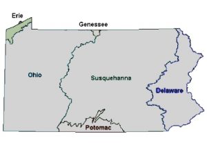
Erie Watershed
- State Water Plan
- Lake Erie Facts
- Land Cover (Percent of Watershed)
- The Great Lakes Region at a Glance
- Regional Climate
Lake Erie Facts
- Name derived from Native American “Erielhonan” tribe, meaning “long-tails,” which once inhabited the area.
- Lake Depth: Average – 62 feet; Maximum – 210 feet
- Lake Volume: 116 cubic miles
- Lake Surface Area:
- Total – 9,910 square miles
- Pennsylvania – 750 square miles
- Basin Area:
- Total – 30,140 square miles
- Pennsylvania – 511 square miles
- Shoreline:
- Total – 871 miles (including islands)
- Pennsylvania – 63 miles
- Major Tributaries:
- Conneaut Creek
- Walnut Creek
- Elk Creek
Land Cover (Percent of Watershed)
| Lake Erie Sub-basin Forest | 40% |
| Agriculture (crop/pasture) | 33% |
| Developed | 15% |
| Wetlands | 4.0% |
| Open Water | <1% |
| Barren (rock/sand/clay) | 5% |
The Great Lakes Region at a Glance
Lake Erie is the southernmost of the five Great Lakes and is also the shallowest, with an average depth of only 62 feet. This makes it the warmest and most biologically active of the Great Lakes and has allowed for a booming commercial fishing industry, as well as many other industries and recreational opportunities.
Because it is part of the largest freshwater resource in the world, Lake Erie’s watershed is densely populated, extensively farmed, and highly industrialized. With drainage from Ontario, Canada and the states of Michigan, Indiana, Ohio, Pennsylvania, and New York, Lake Erie is impacted by the activities of approximately 12 million residents.
The watershed includes 63 miles of shoreline and the only coastal beach, Presque Isle, in the state.
The outlet for Lake Erie is the Niagara River; consequently, it is Lake Erie that feeds water to Niagara Falls.
Lake Erie is the twelfth largest lake in the world (in area), and its border includes four states (New York, Pennsylvania, Ohio, and Michigan) and one Canadian Province (Ontario).
Lake Erie is the only Great Lake with three basins: the western basin includes the islands area; the central basin extends from the islands to about Erie, Pennsylvania, and Long Point, Canada; and the eastern basin extends from Erie, Pennsylvania to the east end of the lake.
Regional Climate
The climate of the Great Lakes Region is generally affected by three factors: air masses from other regions, the basin’s location within a large continental landmass and the moderating influence of the lakes themselves. Weather conditions constantly change as a result of alternating flows of warm, humid air from the Gulf of Mexico and cold, dry air from the Arctic. In addition, the lakes are responsible for moderating temperatures and producing ample precipitation to the region. The lakes act as a giant heat sink—they release stored heat in the fall and winter and are slow to heat up in the spring and summer—which leads to milder seasonal temperatures on land. Evaporation of the lakes’ surface waters adds moisture to the air year-round, which is delivered on-shore as rain or snow.
Sources: